
How can materials support standards based learning?
As the anchor teacher in Opal 3, I have a somewhat unique challenge in guiding project work in the classroom. Our work must align with the state standards for fourth and fifth grade. While the big idea of “early US history” is broad, and the choices of lenses and stories within that context are endless, some state standards don’t seem to allow much choice in how one can approach them. Take, for example, this fifth grade social studies geography standard:
SS.05.GE.01.01 Know and use basic map elements to answer geographic questions or display geographic information.
One of the habits of mind Opal students have is to, “translate their thinking” from one material to another. Through this translation of images and ideas, students slow down, reexamine, and construct deeper meaning for themselves about what they are experiencing. As I was getting ready to send home the first, big homework research project related to our study of US History on geography and map reading, Carole, the school art specialist, recommended that we spend an hour or so letting the students examine maps of their colonies from about 1750 and give them collage materials to see how they might translate and express the meaning they made of the maps.
My teacher brain got worried, “Do they know how to read a map? Will all of those lines and markings make sense to them, especially on these 260 year old map images? Am I setting them up for an exercise in frustration?” But Carole assured me that these materials were powerful and familiar to the children (we used them for our hopes and dreams work in the fall) and that she was confident that they would find meaning in the work.
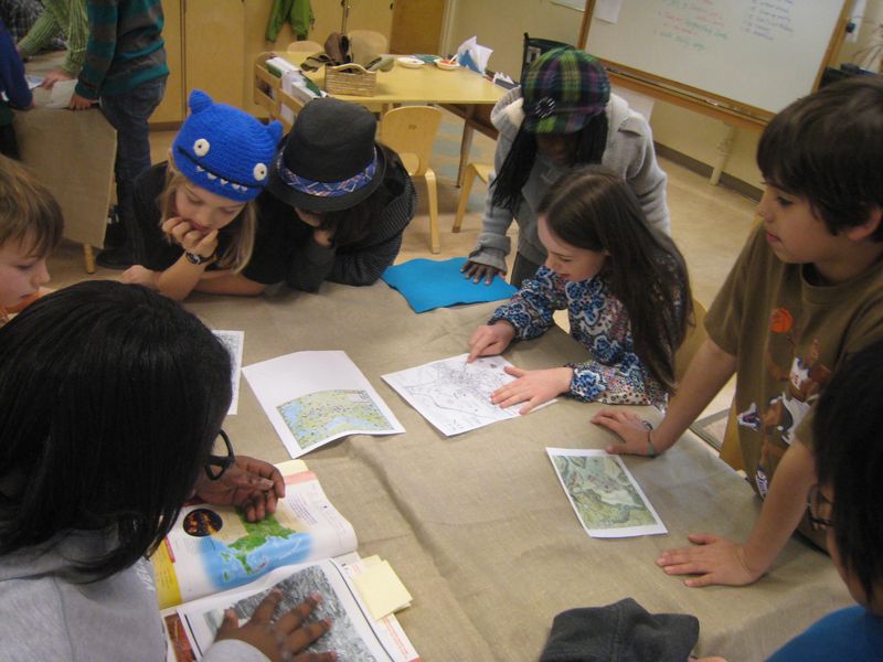
So we went for it. Carole set out materials and images for each group to study. This is the provocation we shared before we sent the students off:
The three cities we are about to study were among the first important European settled port cities in what will become the United States. We know from our work that Europeans had a lot of schema for traveling by boat and over bodies of water. From that we can infer that they knew a lot about what they would look for in choosing a place to establish a port.
Look at how the water meets the land in your port city. What do you notice? How would you imagine a European ship’s captain choosing your city as a port?
What other geographic features do you see in the map of your city? Are there rivers? How might these have been used? Can you tell if there are hills, forests, or even lowlands? Where might the first Europeans to land here have found natural resources like trees for lumber or fresh water fish to eat?
How will the collage materials help you explore the geography of your city?

The students made close observations of the old maps

Some dove into materials while others looked for connections and details in the maps that they could offer to the group. The students seemed to take on roles in their groups according to their strengths and their gifts.

The groups collaborated to create three dimensional representations of their cities. As you look at the images of the cities they created and listen in on what they noticed and wondered, you will see what I learned on this day as a teacher: the kind of learning and thinking that happens when children are engaged in playful inquiry in the presence of materials is deeply meaningful work.

Philadelphia
Teacher: What did you discover?
Lizzie: I didn’t know it was a lot of water. I thought it was forests. The water covers most of the city.
Ella: I was surprised when I saw that there were forts and houses there already. I thought that it would be plain land, a couple of houses already but that would be it.
Mia: It’s pretty flat, it doesn’t have hills.
Harry: When I saw Philadelphia, it reminded me of Seattle. There are a lot of rivers around.

Charleston
Harry: I’ve never been to South Carolina before, I didn’t know it had this much water. There is the Ashley River and the Cooper River, lots of forts, it’s a port city.
Cooper: I wonder how the large bodies of water formed?
Ellie: I thought it was mostly land, but when we looked at the maps there was water everywhere, boats everywhere
Cooper: About 70% of what we made is water.
Danny: There might be settlements outside of the town, but we can’t see on this map.

Boston
Riley: It is smaller than I thought.
Jada: There are lots of piers and lots of hills. Here is Beacon Hill. I thought there wouldn’t be a lot of trees because it’s a city, but there a lot of trees on this map.
Harry: I thought you thought it was an island. It looks like a peninsula.
Alex: What does it look like from inside the town?
